
Drowned Valleys of the Megalopolis
The Greek Word for "Big City"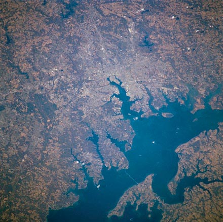
Above: From the Astronaut Photography web site.
From spaceflight.nasa.gov:
Baltimore Area, Maryland, USA: Baltimore, Maryland can be identified in this northwest-looking view of the western shore of Chesapeake Bay. Numerous drowned river valleys provide excellent natural harbors along the periphery of the bay. Baltimore’s harbor has been developed along one of these drowned valleys, the Patapsco River. With a population of over 2.5 million people, the greater Baltimore urban area is part of the northeastern U.S. Megalopolis that extends from the Boston (MA) area to Richmond (VA). Specific features that can be seen in the image include a short segment of Interstate Highway 95 that connects southwest Baltimore with northeast Washington, D.C.; the intersecting runways of Baltimore-Washington International Airport south of downtown Baltimore; Francis Scott Key Bridge that skirts around the southeast side of Baltimore; the Chesapeake Bay Bridge that spans the bay and connects the Baltimore area with the eastern shore of Maryland; and the central business district of Baltimore where the two arms of the inner harbor terminate. The darker-looking vegetation cover is mixed hardwood forests (notice that many wooded areas are located along streambeds and floodplains of small river valleys), while lighter-looking land parcels in the rural countryside is used for crops or pasturelands.

Grouping these large cities together in a single mass seems claustrophobic.*
- - - - - - - - - - - - - - - - - - - - - - - - - - - - -
The photograph below is a satellite image from the NASA satellite "Aqua" from December 31, 2003. Using "Moderate Resolution Imaging Spectroradiometer" (MODIS) this shows some area detail of the geography of the region wherein Richmond lies.
Click to enlarge to see 1355 pixel wide version 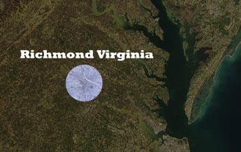
* This reminds me of my Grandpa who lived nearly all his life farming. When I rode with him into a nearby town, which to him was a city, he looked at the proximity of the houses one-to-another and said, "No one could stand being this packed in close unless they were born to it." Long pause. "But when they'd turn eight, they'd start gasping."
Photos by Erik Weems - for prints: prints@erikweems.com